At the edge of the world was a rock
A thousand miles to a thousand miles.
Once in a thousand years a smal bird would come
And sharpen its beak on this rock
When the rock would thus be worn away
Elapsed would be a moment in eternity
— Norse Myth

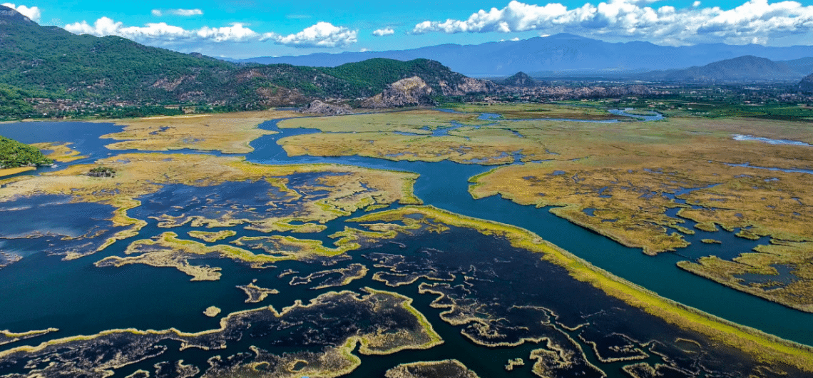
The birth of a unique ecosystem consisting of Köycegiz Lake, the Dalyan River and Delta and the Iztuzu Beach is part of an ancient and great tale concerning the formation of the earth’s crust that started in the Mesozoic Era, 251 millon years ago, and continues today with the changes caused by terrestrial forces.
Theoretically, due to the expansion of the ocean bed, the outer crust of the earth is not fixed. The continents shift on the gummy inner section consisting of molten metals and rocks a few centimetres every year. At the beginning of the Mesozoic Era, there was a very large continent as well as an ocean reaching from the Caribbean to the Himalayas, the name of which was Tethys. While continents resulting from the break-up of this continent due to geological shifts drifted apart the lava erupting from the perpetual splits in the ocean bed cooled down, forming rocks. The folds and breaks that were formed when continents collided by these relatively large movements gave rise to mountain ranges. In this way, the world came close to its present appearance in the Cretaceous Era, some 65 million years ago.
During the Upper Cretaceous Era that began 142 million and ended 65 million years ago, the immense earthquakes by the northward shift of the African continent and its with Eurasia gave rise to dimensional geological motions years ago overlaps in the depths of Tethys. While gravity imbalances raised the Anatolian peninsula, the sedimentary and meta formic rock lates on Tethys’ bed folded and rose along the shores of western and southern Anatolia gradually closed in the course of 20 million years and when the Moroccan Cape and Iberian Peninsula collided and joined, an inland sea disconnected from the ocean was born. This basin, which we today call the Mediterranean was rejoined to the ocean when the Gibraltar bar broke down and took the form of a strait at the end of the Ice Age.
The story of the Köycegiz-Dalyan ecosystem, an enchanting water world comprised of fresh and salty waters as well as thermal springs, started at this point in a wide bay between the promontories of the western extensions of the Taurus mountain range. 18,000 years ago, when the world was going through its latest ice age, vapours condensing around the North Pole and falling on the Polar Cap as snow, formed giant glaciers that went well into Europe causing severe drought in the temperate zone of today. While the Mediterranean fell 100 metres below today’s level, wide salt layers and deserts covered the sea bed.
The glaciers that melted during the global warming of 15,000 years ago combined with the rivers carrying massive amount of water from the increased rainfall, started to refill the basins. While the seas reached their present level about 6,000 years ago, they also swallowed up estuaries. However, the seas (the rising of which gradually lessened), started to fill with silt brought by rivers from the mountains. While former bays and valleys turned into fertile plains, deltas started to form in estuaries.
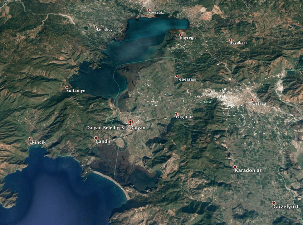
The front of the lagoon in the Köycegiz basin located at the shore of the western Taurus that reached from the Teke Mountain in the east to the Menteş Mountain in the west, was closed with the quarter (sand and gravel) fills from the sea and turned into a 5200-hectare freshwater lake. The lake rose one metre above sea level due to the rivers that fed it. The Dalyan River through which the lake’s waters flowed into the sea formed the nucleus of the Köycegiz/Dalyan ecosystem.
Another factor that gave rise to the present palaeogeographical structure was the Dalaman (Indus) River. The river, a tributary of the Horzum River that springs from the Gündogan Mountains, passes through the deep canyons it has cut through the Taurus Mountains with the high flow rate given it by the abundant springs of the Rahat Mountain, and waters the Dalaman plains during its 200 km. journey, finally completing its course by reaching the sea at the Sarigerme Cove.
Palaeogeographical research has shown that the Dalaman River used to flow into the Dalyan Bay, filling a large part of the Köycegiz basin with the silt it carried forming what is now the Ortaca / Dalyan plains and the Dalyan Delta. The silt accumulation on pebbles and gravelly sand belong to a very wide and deep river bed that can be observed today in the Ortaca plains and the Dalyan Delta, marking the former course of the Dalaman River. Due to a natural occurrence somewhere around 200 BC, the Dalaman (Indus) River shifted its bed passing through the Dalaman River, which started to flow into the Mediterranean from the Sarigerme Cove.
The developments from the Lower Holocene Era through to 200 AD, include the formation of the ecosystem documented by H.Riedel’s palaeogeography research on “The Dalyan Delta and Caunos,” and the story of the foundation, rise and fall of the ancient city of Caunos.
In order to complete a palaeogeographical map, a drilling excavation was conducted. Subsequently it was found that the Dalyan Bay was a wide gulf completely open to the sea in 2000 BC and the peninsula on which the ancient city was founded was located within this bay. The northward-stretching area between the Balıklar Mountain and the rocky Acropolis was in those days, a cove with a small swamp to its west. In the 4th century BC, the coastline would have started from below the rock tombs (those with temple façades) carving itself further out from the middle of what is today’s settlement of Dalyan and reaching Göktepe. The flat land located to the north of this strip and stretching as far as the Köycegiz Lake was covered with swamps up to the north of Uzuntepe, which is to the south of Dalyan and which was then an island close to the shore.
The oldest proof of a settlement found in the Caunos excavations is the neck of an amphora dating back to the Protogeometric period. Although not documented by other proofs, this piceramic dates the founding of the city to 800 BC and maybe even a couple of centuries earlier. In that time the region’s geographical structure was very different from that of today, as the coastline moved in a slightly southwest direction due to silt accumulation, rendering Uzunada (Long Island to Uzuntepe (Long Hill). The north-eastern and eastern parts of the Dalyan Bay became covered with swamps, but the peninsula by which Caunos was founded remained intact. This is because the south and southeast of the Acropolis and the south and west of the small fortress still remains in the sea (Ogün-Işık, 2001)


Many ancient sources such as the famous historian Herodotus of Halicarnassus, the poet and musician Stratokios and geographer Strabo provide very important information on Caunos, which was an important seaport of the time and was strategically important due both to being close to Rhodes and to being situated on the sea routes connecting Eastern Mediterranean with Western Mediterranean and the Aegean Sea. Strabon writes that the river Kalbis, navigable by ships, flowed near Caunos. Palacogeographical research covering 100 BC 200 AD confirms this information. When the front of the foreland forming the south-western spit of the old Dalyan bay was closed with silt and reeds, the “Sulungur” lagoon was formed and the flat land formed when the bay to the north of Caunos was completely filled was inhabited. While the Dalyan River was flowing almost in its present, the land on which the present Dalyan town was founded and the part in front of the Acropolis and the Small Fortress became flat land, swamps and river flood plains and Caunos’s southern port gradually became unusable (Ögün-Işık, 2001).
After 200 BC the Dalyan River connected to the sea through the skirts of the Acropolis for a while but then started to follow a course close to its present bed. While a large alluvial plain formed at the south of the Acropolis and around the town of Dalyan, a 1700-hectare delta took shape. Covered with ponds fingered out into tall reeded waterways extending from behind the Iztuzu beach, this delta’s foundational ecosystem is much the same today.
Source: Koycegiz – Dalyan A Journey Through History Within The Labyrinth of Nature, (pages: 13-18), Altan Türe, 2011, Faya Kültürel Yayınları
Comments